

1195 LESSON 14514 WEDNESDAYFREE ONLINE E-Nālanda Research and Practice UNIVERSITY![]()
KINDLY TRANSLATE THIS “APPEAL” IN YOUR
CLASSICAL MOTHER TONGUE AND ALL THE OTHER LANGUAGES YOU KNOW AND
PUBLISH. Please send a copy to
awakenmedia.prabandhak@gmail.com
chandrasekhara.tipitaka@gmail.com
Visit:
http://sarvajan.ambedkar.org
MAY YOU LIVE LONG!
MAY ALL SENTIENT AND NON-SENTIENT BEINGS BE EVER HAPPY!
MAY YOU ALWAYS HAVE CALM, QUIET,
ALERT,ATTENTIVE AND
EQUANIMITY MIND WITH A CLEAR UNDERSTANDING THAT
EVERYTHING IS CHANGING!
https://itunes.apple.com/us/album/lot…
Peaceful
Music, Most Relaxing and Soft Music, New Age Music, Relaxation, Yoga,
Music for sleeping, Musica para Dormir. Dream Music Lullaby 432hz
1:03:16mins
https://www.youtube.com/watch?v=FA0wAheWjYw
http://www.360cities.net/image/the-tallest-stone-buddha-sculpture-in-the-world-japan#0.00,-16.70,110.0
http://www.360cities.net/image/pa114982-panoramata-japan#383.69,-15.72,110.0
http://www.360cities.net/
http://www.ancient-buddhist-texts.net/Maps/Growth-of-Buddhism.htm
Maps of Ancient Buddhist Asia
Some Maps illustrating the Growth of the Buddha Sāsana


RELIGION-BUDDHA
Heritage site, the Mahabodhi Temple is illuminated with lights on the
occassion of the 2558th Buddha Jayanti celebrations at Bodhgaya on May
12, 2014. Buddha Jayanti, the most sacred Buddhist festival, celebrates
the birthday of Lord Buddha and commemorates his Awakenment and
death. It is held on a full moon in May each year and in 2014, Buddha
Jayanti falls on May 14. AFP PHOTO (Photo credit should read
STR/AFP/Getty Images)
Buddha Jayanti celebrations in Bodhgaya.
Buddha Purnima today
DHAKA : Buddha Purnima, the biggest religious festival of the
Buddhist Community will be observed in the country today, reports UNB.
Buddha Purnima is a festival that marks Gautam Buddha’s birth,
enlightenment and death. It falls on the day of the full moon in May.
Lord Buddha was born on the full moon day in 563 BC, achieved enlightenment and nirvana (passing away) on the same day.
Different Buddhist organisations have chalked out various programmes to celebrate the day. The day is a public holiday.
President Abdul Hamid, Prime Minister Sheikh Hasina and BNP Chairperson
Khaleda Zia, in separate messages, greeted the Buddhist community on the
occasion.
In a message, President Abdul Hamid said Bangladesh is a country of
communal harmony where all citizens can practice their religion freely.
He also hoped that the people of Buddhist community will play an
important role in the development of the country.
In a separate message, Prime Minister Sheikh Hasina said Gautam Buddha
preached the messages of friendship, mercy and non-violence throughout
his life.
MAHA BODHI SOCIETY, BENGALURU, INDIA
21558th SACRED BUDDHA JAYANTI
CELEBRATIONS 2014

VESAKHA BUDDHA PURNIMA
ಪವಿತ್ರ ವ್ಯೆಶಾಖ ಬುದ್ಧ ಪೂರ್ಣಿಮಾ
14-05-2014
Pabbajja Courses for
Children : 27-04-2015 to 04-05-2010
Men & Women : 07-05-2014 to 15-05-2014

10 Famous Buddha Statues
The study of Buddhism has inspired some of
the world’s most beautiful contributions to the world of art, most
notable in the form of statues known as Buddharupa (literally, the form
of the Awakened One) that adorn Buddhist temples of worship. Listed here
are ten of the world’s most famous and beautiful statues celebrating
the Awakened One and his message of peace.
Some of these Buddha statues are among the largest in the world. A comparison between these and other great statues in the world can be found here.
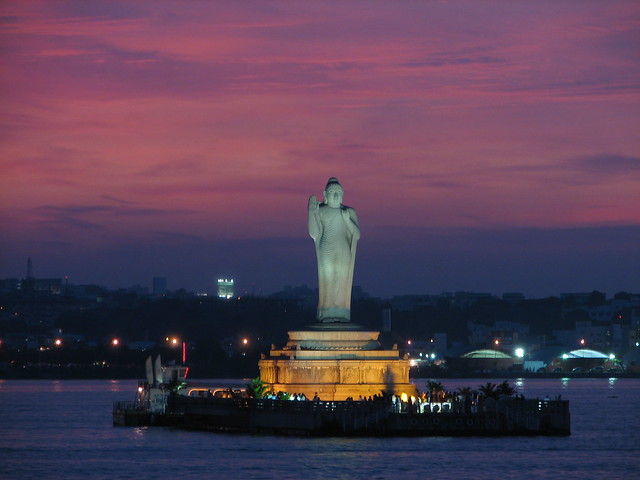 flickr/aloshbennett
The Buddha statue situated at the center of an artificial lake in the
city of Hyderabad is one of India’s most famous Buddha statues. This
figure stands at a full 17 meters (56 feet) tall and weighs 320 tons.
The single largest monolithic statue in all of India, it was sculpted by
a group of artisans from a single piece of stone. Tragically, during
the statue’s installation in 1992 the figure tipped over and fell into
the lake, causing the death of 8 workers. The government recovered the
statue and restored it to its full height and stature.
 flickr/Mark McLaughlin
Tian Tan Buddha sometimes locally referred to as the Big Buddha, is
located on Lantau Island, in Hong Kong. Fashioned of bronze and
completed in 1993, The statue is the main feature of the Po Lin
Monastery, symbolizing harmony between man, nature, people and religion.
The statue is named Tian Tan Buddha because its base is a replica of
Tian Tan, the Temple of Heaven in Beijing. The statue sits on a lotus
throne on top of a three tiered altar. At 34 meters (110 feet) tall,
the Tian Tan Buddha is presented in a posture of serenity. His right
hand is raised to remove affliction. His left hand rests on his knee,
representing happiness.
 flickr/patrikmloeff
Monywa is a city in central Myanmar located on the banks of the
Chindwin River. Just east of the city is the Po Khaung Taung, a range of
hills where you can see the Monywa Buddha– the largest reclining Buddha
statue in the world. This colossal figure measures 90 meters (300 feet)
in length. The head alone is 60 feet high. The Monywa Buddha was
constructed in 1991 and is hollow inside, allowing visitors to walk
along from the head to the feet. Inside the figure are 9,000
one-foot-high metal images of the Buddha and his disciples, depicting
various representations of important events in the Buddha’s life.
Recently a gigantic standing Buddha statue was built on top of Po
Kaung Hills. At 132 meter (433 feet) high it is one of the largest
Buddha statues in the world.
 flickr/Ren
Thailand’s city of Ayutthaya is the location of one of the world’s
most unusual Buddhist statues. Among the ruins of Wat Mahathat (The
Temple of the Great Relic) is the remains of a sandstone statue of the
Buddha whose body has been lost to the ages but whose head rests
appropriately in the climbing roots and vines of a tree. Around this
famous figure are many other stature of the Ayutthaya period which have
survived the ravages of time.
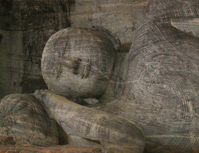 flickr/DennisSylvesterHurd
Located in north central Sri Lanka, Polonnaruwa is the site of one of
the most breathtaking of the world’s representations of the Buddha –
the Gal Gal Viharaya. This massive rock temple was constructed by
Parakramabahu the Great in the 12th century. The central attraction of
the temple are 4 large Buddha statues carved into the face of a granite
boulder. Among these giant stone figures are a reclining statue of the
Buddha that measures 14 meters (46 feet) in length and a standing figure
measuring 7 meters (23 feet) high.
 flickr/tsukubajin
The Ushiku Daibutsu is located in the city of Ushiku in Japan.
Finished in 1995, the figure is one of the world’s tallest statues,
standing a total of 120 meters (394 feet) high including the 10m (30
foot) base and 10m high lotus platform. Visitors to the Buddha statue
can take an elevator to a platform where an observation deck is
situated. The bronze-plated figure depicts Amitabha Buddha, and is also
known as Ushiku Arcadia.
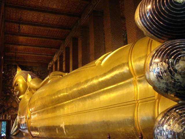 flickr/SJ Jagadeesh
Located in Bangkok,
Wat Pho is famous for the huge Reclining Buddha statue it houses. It is
one of the largest temples in Bangkok and also one of the oldest,
constructed nearly 200 years before Bangkok became Thailand’s capital.
Wat Pho holds the distinction of having both Thailand’s largest
reclining Buddha image and the largest number of Buddha images in
Thailand. The gold-plated Reclining Buddha statue is 46 meters long and
15 meters high, and commemorates the passing of the Buddha into Nirvana.
The statue’s eyes and feet are decorated with engraved mother of pearl,
the soles of the feet displaying the 108 auspicious characteristics of
the true Buddha.
 flickr/enggul
The Kotoku-in is a Buddhist temple of the Jodo shu sect located in
the city of Kamakura in Japan. The temple is famous for its great
Buddhist statue (or daibutsu). a colossal outdoor representation of
Amida Buddha, one of Japan’s most celebrated Buddhist figures. Cast in
bronze, the Great Buddha stands at over 13 meters (40 feet) high and
weighs nearly 93 tons.
The statue reportedly dates from 1252 and is generally believed to
have been cast by the Buddhist monk Joko, who also collected donations
to build it. Although it originally was housed in a small wooden temple,
the Great Buddha now stands in the open air as the original temple was
washed away in a tsunami in the 15th century.
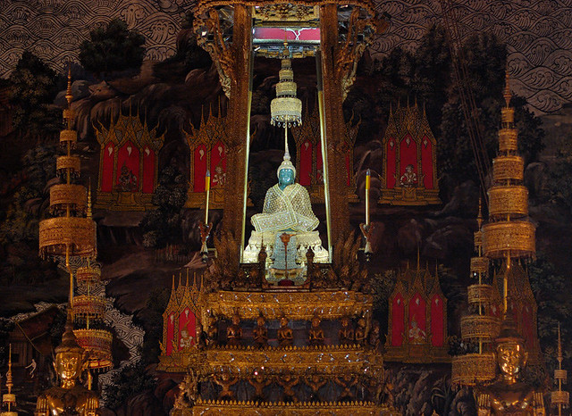 flickr/amangupta
Another of Bangkok’s Buddhist temples is Wat Phra Kaew, the Temple of
the Emerald Buddha, located within the grounds of the Grand Palace. The
main building is the central ubosoth, which houses The Emerald Buddha,
one of the oldest and most famous Buddha statues in the world.
A jade statue adorned in gold clothing, the Emerald Buddha was,
according to legend, created in India in 43 BC in the city of
Pataliputra, where it remained for 300 years. In the 4th century AD it
was taken away to Sri Lanka by Buddhist monks to save it from
destruction by war. Eventually the statue made its way to Thailand and
was moved to Wat Phra Kaew in 1779. The statue has three different sets
of gold clothing, which are changed by the King of Thailand in a
ceremony at the changing of the seasons.
 flickr/drs2biz
The Giant Buddha of Leshan is a gigantic Buddha statue carved out of a
cliff face in Sichuan, western China. The great sculpture is a figure
of Maitreya — a Bodhisattva traditionally represented in sitting
posture. Begun in the year 713 during the Tang Dynasty, the statue was
not completed until the year 803, and was the effort of thousands of
sculptors and workers. As the biggest carved stone Buddha in the world,
the Leshan Giant Buddha is featured in poetry, song and story. The
sculpture stands about 71 meters (233 feet) high and has three meter (11
feet) long fingers on each of its enormous resting hands. Today it is a
popular tourist attraction in China.
12th May 2014 Monday 10 am
Venue: District Prison, Mandya
PRISONERS SERVICE DAY
Self Correction – Finding Peace
Talk and guided meditation by
Venerable Ananda Bhanteji
13th May 2014 Tuesday 3 pm
Venue: Ashwini Hall, NIMHANS, Bengaluru
MENTAL PATIENTS SERVICE DAY
Guests
Sri.B.Gopal
President, Praja Parivarthana Vedike
Dr. Sathischandra
Director and Vice Chancellor, NIMHANS
Presided by
Venerable Ashin Nodinyana Bhanteji
Professor of Pali and Abhidhamma, Myanmar
Blessings by
Venerable Ananda Bhante
14-05-2014 Wednesday 10 am
Venue: Maha Bodhi Society, 14, Kalidasa Raod, Gandhinagar, Bangalore-560009
VESAKHA
SACRED BUDDHA PURNIMA DAY
10 AM – Sanghadana and Pindapata Puja
11
AM - Sri Maha Bodhi Puja, Vishwa Maitri Stupa Puja, Siripada Cetiya
Puja Buddha Puja at Mahabodhi Loka Shanti Buddha Vihara, Undertaking of
Tisarana, Atthasila and Pancasila
Dhamma Desana by
Venerable Ananda Bhante
General Secretary, Maha Bodhi Society, Bengaluru
Blessings by
Venerable Ashin Nodinyana
Professor of Pali and Abhidhamma, Myanmar
Buddha Purnima Day Address by
Nadoja Dr. Ham pa Nagarajaiah
Famous Kannada Author and Thinker
Release of Books by
Dr. M. G.Krishnan
Vice Chancellor, Karnataka State Open University, Mysore
Books to be released
Perspective of Buddhism – 30 Dhamma talks by Venerable Acharya Buddharakkhita
Sutta Nipata – Kannada translation by Sri Anish Bodh
Upasakarige Boudha Anushasana – by Sri Anish Bodh
Sutta Sara Kaipidi by Smt.Gayathri Chabbi
Mahabodhi Samsthegalu – Kiru parichaya by Dr.B.V.Rajaram
1.30 PM : Meals for Devotees
Meals Dana by
Upasakas B.Gopal, Dr.Jayprakash, Dr.Ramachandra, Sri Subbanna and family members
2.30 to 4.30PM
Dhamma Deeksha, meditation programs and Dhamma discourses
6.00PM
Vesakha Purnima Dhamma Discourse
Special Puja and Blessing Ceremony by
Venerable Ashin Nodinyana
Professor of Pali and Abhidhamma, Myanmar
7:30 Deepa Puja
We thank all the donors who have generously helped us to make these programs successful.
Books on Buddhism are available on discounts from 7-14 May 2014
SPECIAL PALI COURSE
A
special Pali Course is being held at Maha Bodhi Society, Bengaluru,
from 3-27 May 2014, 6 PM -7:30 PM daily by Venerable Ashin Nodinyana,
Professor of Pali & Abhidhamma, International Theravada Buddhist
University, Yongon, Myanmar. Interested people may enroll with Mr.Ravi –
08548823222
Mahabodhi
Center for Theravada Buddhist Studies is conducting One-Year Diploma,
3-years Undergraduate, 2-year Masters degree and Ph.D courses in
Theravada Buddhist Studies. Please contact after 16th May onwards the
Director at the Mahabodhi Office.
BHAGAVAN BUDDHA
2558th SACRED BUDDHA JAYANTI
Will be observed as BODHI SAPTAHA
From Thursday 8th May 2014 to Wednesday 14th May 2014
With main funcion on 14-05-2014 Vesakha Purnima Day
We cordially invite you to attend all the programs
with family and friends.
Yours,
President and Members,
Maha Bodhi Society, Mahabodhi maitri mandala,
Mahabodhi Centre for Theravada Buddhist Studies,
Mahabodhi Foundation, Baghavan Buddha University,
Mahabodhi Research Centre,
Buddha Vachana Trust, Nalanda Vijjayatana
and Mahabodhi Branches in Mysore, Arunachal pradesh, Tripura
Address for correspondence and donations;
MAHA BODHI SOCIETY
14, Kalidasa Road, Gandhinagar, Bangalore-560009, India
Tel: 080-22250684, 09343158020, Fax: 080-41148440
Email:info@mahabodhi.info Web site: www.mahabodhi.info
Donate generously and share merits
Buddha Jayanti, also known as Buddha Purnima, celebrates the birthday
of Lord Buddha. It also commemorates his enlightenment and death. It’s
the most sacred Buddhist festival.


http://www.ancient-buddhist-texts.net/Maps/Map-16-Indian-Buddhist-Art-Schools.htm
Jambudīpe Boddhakalā Paraṁparā
Indian Buddhist Art Schools
Note that the Empires
which give their names to the art periods described below waxed and
waned, sometimes over many centuries. The borders of the Empires on
these maps generally show what they were like at their greatest extent,
and at other times they may have been much smaller. The periods given
for the Empires sometimes overlap each other when they prevailed in
different parts of the country.
Mauryan Period, 322–185 BC

The remains from the Mauryan period are very few, they
consist mainly of the Asokan Rock Edicts and the Pillars, which are
normally inscribed and surmounted by lions, elephants or bulls (only a
small selection of them are shown here). In Kumraha on the edge of
modern day Patna are old architectural remains of the ancient city
walls, and from Didarganj on the banks on the Ganges a splendid
human-size Yakṣinī modelled in the round, and highly polished, has been
found. The excavated rock caves at Barabar, although later inhabited by
Buddhists, were carved out for the Ājīvaka sect, but their main
importance lies in the fact that they provided the models for the great
rock cave complexes at Ajāntā, Ellora and eslewhere in the coming
centuries.
Sunga Period, 185–75 BC

After the fall of the Mauryans a new dynasty arose
called the Sungas. The stūpas at Sāñchi and Bhārhut, although originally
built during the Mauryan period, were rebuilt and expanded during the
Sunga period, and it is the work carried out beginning at this later
period that we see today, including the dome, the stone casing and the
harmika. It was also during their reign that the Chaitya at the Bhaja
Caves at Karli in Maharashtra was built.
Sātavāhana Period, circa 2c BC–2c AD

With the
collapse of the Mauryan Empire, the kingdoms
in the south of India were united by the Sātavāhana dynasty, and it is
during this time that the great railings at Sāñchi, Bhārhut and
Amaravati were made. The elaborate carvings found on these monuments are
the main sources for the aniconic period of Buddhist art, in which the
Buddha was represented only by symbols, such as the Vajrāsana, the Bodhi
Tree, the Dhamma-Wheel and the Siripāda, or Holy Feet. It was also at
this time that the rock-cut Temples at Ajāntā and Ellora and the other
cave complexes in the western regions were first carved out. The
Sātavāhanas were succeeded by the short-lived Ikshvāku dynasty (2c AD–3c
AD), and it was during this time when the great stūpas were built at
Nāgārjunakoṇḍa and elsewhere.
Gandhāra Period, 1 BC–5 AD

Following
the invasions of Alexandria in the 3rd
century B.C., many of the Greek forces settled on the borders of India,
giving rise to the syncetric Greco-Indic civilisations at Gandhāra, in
what is modern day Pakistan and Afghanistan. In this confluence of
cultures the first statues and reliefs of the Buddha were made. They
were evidently modelled on the Greek statues of Apollo, and present the
Buddha with Caucasian facial features, and flowing, wavy hair on the
head. The halo behind the Buddha’s head is plain. During the Kuṣāṇ
period (1c AD–3c AD) this empire stretched right into the heartland of
India, and also gave rise to the great and influential atelier at
Mathura.
Gupta Period, 4c–6c AD

The Gupta Empire was centered around their capital at
Pāṭaliputra in modern-day Bihar, and is normally thought of as the
Golden Age of Indian artistic creation. It is during this period that
the murals we find in Ajāntā and Ellora were begun, which provide the
earliest examples of Indian painting. Also during this time the great
universities at Nālanda, Vikrāmaśīla and elsewhere were built, and they
in turn gave rise to great schools of sculpture and bronze casting, all
with classical elagance. In this period the Buddha figures are modelled
with the characteristic curly ringlets of hair, and sheen-like
close-fitting robes. The halos are normally decorated in this period.
Pāla Period, 8c–12c AD

The Pāla Empire grew up in the eastern areas of India,
in what is now Bihar and Bengal, both east and west, but during the
height of their power their Empire also reached as far as the Kabul
valley in modern-day Afghanistan. The universities were still
flourishing during this time, and there are very many architectural and
sculptural remains from this period. The art of this period is much more
elaborate and intricate in style. We see at this time a great
fourishing of representations of the various Bodhisattvas and gods in
the developed Buddhist pantheon. It was towards the end of their reign
that the Muslim invasions finally brought Buddhism to an end in India,
and with it the Buddhist art traditions there. Before that had happened
though, Buddhist culture and art had spread all over Asia.
Photo Credits:
on Map 1 (Asokan Capital): mself
on Map 2 (Bhaja Cave): Elroy Serrao
on Map 3 (Amaravati Relief): Gurubrahma
on Map 4 (Gandhāran Buddha Head): Phg
on Map 5 (Standing Buddha): Ānandajoti Bhikkhu
on Map 6 (Bronze Sitting Buddha): Ānandajoti Bhikkhu
All Released with Creative Commons, Attribution, Share-Alike licenses, or into the Public Domain.
http://www.ancient-buddhist-texts.net/Maps/MP-index.htm
During Lord Buddha’s Time
Tathāgatassa Pure Caritaṁ
The Realised One’s Early Career

The map shown above is approx. 550 km from East to West and 400 km from North to South
There is a video of an
hour-long talk I gave using this map as a basis to explain more about
the Buddha’s movements before and after his Awakening.
It can be seen on YouTube
Some of the modern place names, where they differ, are given here:
Uruvelā = Bodhgaya; Bārāṇasī = Varanasi; Isipatana = Sarnath; Rājagaha =
Rajgir; Vesālī = Vaishali; Kapilavatthu = Kapilavastu.
What follows is based on the account in the
Mahākhandhaka section of the Vinaya Mahāvagga, and the traditional
histories such as the Jātaka Nidānakathā, and the Jinavaṁsa:
After Awakening at the foot of the Bodhi tree in Uruvelā the Buddha
spent the following 7 weeks in a number of locations in the same area.
He then travelled to Isipatana, where his former companions, the group
of five (pañcavaggiya) ascetics were staying. The walking tour appears to have taken around a week, as he arrived on the Full Moon night of Āsāḷha.
That night he preached his first recorded discourse, and thereby set
the Dhamma-Wheel rolling, at the end of which Aññāta Koṇḍañña became the
first person to attain Path and Fruit in the present Sāsana. In the
next few days he and his four companions all became Worthy Ones (Arahanta).
The Buddha spent the first Vassāna in the Deer-Park at Isipatana, and
in a short time converted first Yasa, and then 50 of his friends, who
also all became Worthy Ones.
At the end of the Rain’s Retreat the Buddha walked back to Uruvelā,
where he converted the three Kassapa brothers and their 1,000 disciples.
From there he travelled to the Magadhan capital Rājagaha, where he was
presented with his first monastery, the Bamboo Wood (Veḷuvana) by King Bimbisāra.
Five months had passed since leaving Isipatana and it was now
Springtime. Kāḷudāyī arrived from Kapilavatthu, and invited the Buddha
to return to his home town. There he converted his former Wife, his
Father, and ordained his Son, and other family members, including Nanda
and Ānanda.
After these conversions he returned once again to Rājagaha, and while
he was there the rich merchant Anāthapiṇḍika arrived and invited him to
Sāvatthī, where he bought and presented him with the Jeta’s Wood
monastery. At this point the early histories break off, perhaps because
the Sāsana was safely established by this time. Although we know a lot
about the Buddha’s ministry, the chronology is not picked up again until
the Mahāparinibbānasutta opens about one year before the Final
Emancipation at Kusinārā.
Tathāgatassa Vassā
The Realised One’s Rains Retreats

The map shown above is approx. 550 km from East to West and 400 km from North to South
Some of the modern place names, where they differ, are
given here: Isipatana = Sarnath; Rājagaha = Rajgir; Vesālī = Vaishali;
Kosambī = Kausambi; Kapilavatthu = Kapilavastu. Nāḷaka is either
Nalanda, or is nearby; Āḷavī is unidentified as yet.
This map shows the various places where the Buddha
spent his Rain’s Retreats according to the information related in the
Introduction to the Commentary on the Buddhavaṁsa, which is also
followed by Ven. Medhaṅkara in Jinacarita. Most of them are well known,
and appear in the Discourses many times. Of the Retreats we are sure
about note that they all were taken in the Middle Lands (Majjhimadesa).
Some of the places we cannot identify. These include the 6th retreat on Mount Maṅkula;01 8th at Bhesakalā Wood in the Bhagga Country; 13th, 18th and 19th on Mount Cāliya.02
Others are only vaguely known, such as Silk-Cotton Wood, Pārileyya and
Verañjā, all of which were around Kosambī. The exact position of Āḷavī
is also not known, but must have been in the Vajjī Country where there
were many yakkha shrines. According to tradition the 7th Rains Retreat
was spent in Tāvatiṁsa teaching the Abhidhamma to his Mother, who had
been reborn as a Devaputta.
The information given in the Commentary inexplicably
omits the last Rain’s Retreat spent by the Buddha, which was at the
village of Beluva, within walking distance of Vesālī, as related in the
Mahāparinibbānasuttaṁ. A text and translation of the relevant section of
the Commentary to Buddhavaṁsa follows (for a later, and more poetic
description of the Rains Retreats, see Jinacaritaṁ):
from Madhuratthavilāsinī (Buddhavaṁsatthakathā), Ganthārambakathā:
Paṭhamaṁ Vassaṁ Isipatane Dhammacakkaṁ pavattetvā aṭṭhārasa Brahmakoṭiyo amatapānaṁ pāyetvā
After setting the Dhamma Wheel Rolling in Isipatana and making
180,000,000 Brahmās imbibe the immortal ambrosia during the first Rains
Retreat
Bārāṇasiṁ upanissāya Isipatane Migadāye vasi;
he dwelt at the Deer Park in Isipatana relying on Bārāṇasī (for alms);
dutiyaṁ Vassaṁ Rājagahaṁ upanissāya Veḷuvane Mahāvihāre;
the second Rains retreat was in the Great Monastery at Bamboo Wood, relying on Rājagaha;
tatiyacatutthāni pi tattheva;
the third and fourth likewise (he was) also there;
pañcamaṁ Vesāliṁ upanissāya Mahāvane Kūṭāgārasālāyaṁ;
the fifth was in the Gabled House Hall in the Great Wood relying on Vesālī;
chaṭṭhaṁ Maṅkulapabbate;
the sixth on Mount Maṅkula;
sattamaṁ Tāvatiṁsabhavane;
the seventh in the realm of the 33 gods (Tāvatiṁsa);
aṭṭhamaṁ Bhaggesu Saṁsumāragiriṁ upanissāya Bhesakaḷāvane;
the eighth in the Bhesakaḷā Wood, relying on the Crocodile Hill amongst the Bhaggas;
navamaṁ Kosambiyaṁ;
the ninth near Kosambī (at Ghositārāma);
dasamaṁ Pārileyyakavanasaṇḍe;
the tenth in the Pārileyyaka grove;
ekādasamaṁ Nāḷāyaṁ brāhmaṇagāme;
the eleventh in the brāhmin village of Nāḷa (in Magadhā);
dvādasamaṁ Verañjāyaṁ;
the twelfth near Verañjā;
terasamaṁ Cāliyapabbate;
the thirteenth on Mount Cāliya;
cuddasamaṁ Jetavanamahāvihāre;
the fourteenth in the Jeta’s Wood great Monastery (near Sāvatthī);
pañcadasamaṁ Kapilavatthumahānagare;
the fifteenth near the great city of Kapilavatthu (at the Nigrodhārāma, near his home town, amongst the Sākiyans);
soḷasamaṁ Āḷavakaṁ dametvā caturāsītipāṇasahassāni amatapānaṁ pāyetvā Āḷaviyaṁ;
having tamed (the yakkha) Āḷavaka and making 84,000 creaturess imbibe the immortal ambrosia, (he spent) the sixteenth at Āḷavī;
sattarasamaṁ Rājagahe yeva;
the seventeenth was surely near Rājagaha (perhaps in Bamboo Wood);
aṭṭhārasamaṁ Cāliyapabbate yeva tathā ekūnavīsatimaṁ;
the eighteenth on mount Cāliya and then also the nineteenth;
vīsatimaṁ pana Vassaṁ Rājagaheyeva vasi;
but the twentieth Rains Retreat he dwelt near to Rājagaha (perhaps in Bamboo Wood);
…
Tato paṭṭhāya pana Sāvatthiṁ yeva upanissāya
But from there onwards he surely relied on Sāvatthī
Jetavanamahāvihāre ca Pubbārāme ca dhuvaparibhogavasena vasi.
dwelling in the Great Monastery in Jeta’s Wood and the Eastern Monastery
because it had constant supplies (of requisites for the large gathering
of monks).
Tathāgatassa Pacchimā Cārikā
The Realised One’s Last Tour

The map shown above is approx. 550 km from East to West and 400 km from North to South
There is a video of an hour-long talk I gave using this map as a basis to explain more about the last year of the Buddha’s life.
It can be seen on YouTube
Some of the modern place names, where they differ, are given here:
Rājagaha = Rajgir; Pāṭaligāma = Patna; Koṭigāma = Hajipur; Vesālī =
Vaishali; Pāvā = Fazilnagar and Kusinārā = Kushinagar. Other places are
uncertain or unidentified.
The last year of the Buddha’s life is recorded in the Mahāparinibbānasutta of the Dīghanikāya (DN 16), which records his last walking tour in the Middle Country (Majjhimadesa). Before the beginning of the Rains Retreat (Vassāna)
the Buddha walked from Rājagaha to Vesālī (approx. 90 km) where he
stayed for a number of months. Eventually the Buddha left Vesālī and
started walking North and attained Complete Emancipation (Parinibbāna) at Kusinārā (approx. 270 km, quite a walk when 80 years old and ill).
Looking at the map it very much appears as though the Buddha was
actually heading for his home town of Kapilavatthu but succumbed to his
illness on the way. The Buddha fell ill with dysentry in Pāvā and
according to the very sad story in the Commentary, on the last day of
his tour he actually had to sit down and rest no less than 25 times
before reaching Kusinārā in the evening.
http://www.ancient-buddhist-texts.net/Maps/Map-09-Relics.htm
Sarīravibhāgo
The Distribution of the Relics

The map shown above is approx. 550 km from East to West and 400 km from North to South
The exact positions of Pipphalivana, Allakappa, and Veṭhadīpa are not
known. One of the more interesting things this map brings out is that
Sāvatthī and Bārāṇasī did not get a share of the relics, and apart from
the relics that were taken to Vesālī and Rājagaha, all the others were
distributed locally.
Some of the modern place names, where they differ, are given here:
Kapilavatthu = Kapilavastu; Pāvā = Fazilnagar; Kusinārā = Kushinagar;
Rāmagāma = Ramgram; Rājagaha = Rajgir; Vesālī = Vaishali; Rājagaha =
Rajgir.
from Mahāparinibbānasuttaṁ
- Then the Magadhan King Ajātasattu, the son of Lady Wisdom, made a
Shrine for the Gracious One’s bodily relics at Rājagaha and held a
festival. - The Licchavīs from Vesālī made a Shrine for the Gracious One’s bodily relics at Vesālī and held a festival.
- The Sakyas from Kapilavatthu made a Shrine for the Gracious One’s bodily relics at Kapilavatthu and held a festival.
- The Bulas of Allakappa made a Shrine for the Gracious One’s bodily relics at Allakappa and held a festival.
- The Koliyas of Rāmagāma made a Shrine for the Gracious One’s bodily relics at Rāmagāma and held a festival.
- The Veṭhadīpaka brahmin made a Shrine for the Gracious One’s bodily relics at Veṭhadīpa and held a festival.
- The Mallas of Pāvā made a Shrine for the Gracious One’s bodily relics at Pāvā and held a festival.
- The Mallas of Kusinārā made a Shrine for the Gracious One’s bodily relics at Kusinārā and held a festival.
- Doṇa the brahmin made a Shrine for the urn and held a festival.
- The Moriyās of Pipphalivana made a Shrine for the ashes at Pipphalivana and held a festival.
- Thus there were eight Shrines for the bodily relics, the Vessel
Shrine was the ninth, and the Ashes Shrine was the tenth, and so it was
former times.
http://www.ancient-buddhist-texts.net/Maps/Map-01-Four-Places.htm
Cattāri Saṁvejanīyāni Ṭhānāni
The Four Places that Produce Enthusiasm

The map shown above is approx. 550 km from East to West and 400 km from North to South
The modern place names are given here: Uruvelā = Bodhgaya; Isipatana = Sarnath; Kusinārā = Kushinagar.
from Mahāparinibbānasuttaṁ, Section 35:
These are the four places, Ānanda, that are to be seen that produce
enthusiasm for a faithful man of good family. Faithful monks, nuns,
laymen, and laywomen will come, (thinking): ‘Here the Realised One was
born’, ‘Here the Realised One awoke to the unsurpassed and Perfect
Awakening’, ‘Here the Realised One set rolling the Wheel of the
Teaching’, ‘Here the Realised One was Completely Emancipated in the
Emancipation-element which has no basis for attachment remaining’, and
whoever, Ānanda, will die while on pilgrimage to the Shrines with a
confident mind they will all, at the break-up of the body, after death,
re-arise in a fortunate destiny, in a heavenly world.
* * *
To give some idea of the distances involved: when the Bodhisatta left
Kapilavatthu he walked down to Rājagaha, which is approx. 360 km; from
Rajagaha he walked down to Uruvelā (approx. 80 km south), which is where
he practiced and attained Awakening; after Awakening he walked over to
Isipatana near Bārāṇasī (approx. 250 km). On his last walking tour at
the age of 80, he first walked from Rājagaha to Vesālī (approx. 90 km,
and after the Rains Retreat from Vesālī to Kusinārā (approx. 270 km),
quite a feat for someone who was 80 years old and ill.
http://www.ancient-buddhist-texts.net/Maps/Map-03-Parayana.htm
Bāvarissa Māṇavacārikā Jambudīpe
Bāvarī’s Students’ Walk across Ancient India

The map shown above is approx. 1,600 km from East to West and 1,200 km from North to South
from Pārāyanavaggo, verses 31-38:
After hearing Bāvarī’s words, the sixteen brahmin students …
set out for the North. From Mūḷaka to Patiṭṭhāna first, then on to
Mahissati, to Ujjenī, and Gonaddha, to Vedisa, and to the place called
Vanasa, to Kosambī, and Sāketa, and Sāvatthī, the city supreme, to
Setabya, and Kapilavatthu, and to the city of Kusinārā, to Pāvā, to
Bhoganagara, to Vesālī, to the Magadhan city (Rājagaha), and to the
Pāsāṇaka Shrine, delightful, it is the mind’s delight.
Bāvarī had left Sāvatthī, the capital of Kosala, some time before
and retired to a very remote place on the bank of the Godhāvarī River,
which was about as far south as the Ariyans had penetrated at that time.
There students gathered around him, including 16 who became teachers in
their own right. When Bāvarī heard that a Sambuddha had arisen in the
world he sent his students to question him. They first headed for
Sāvatthī itself, where the Buddha had been staying, but when he saw them
coming, realising that they were not mature enough, he withdrew to
Rājagaha and to the Pāsāṇaka Shrine. Their walking tour covered a
distance of some 1,800 kilometres.
http://www.ancient-buddhist-texts.net/Maps/Map-04-Janapada.htm
Soḷasa Mahājanapadā
The Sixteen Great States

The map shown above is approx. 1,600 km from East to West and 1,200 km from North to South
In two places in the Aṅguttaranikāya (Uposathasuttaṁ, Bk. 3.71;
Vitthatūposathasuttaṁ, Bk. 8.42) we find the following list of great
states (Mahājanapadā): Aṅgā, Magadhā, Kāsī, Kosalā, Vajjī, Mallā, Cetī, Vaṁsā,01 Kurū, Pañcālā, Macchā, Sūrasenā, Assakā, Avantī, Gandhārā, Kambojā.02
We sometimes come across other forms of this list, so that at
Janavasabhasuttaṁ (DN 18) only the following ten are mentioned: Kāsī,
Kosalā, Vajjī, Mallā, Cetī, Vaṁsā, Kurū, Pañcālā, Macchā,03 Sūrasenā. Interestingly, the Sākiyas and the Koḷiyans are omitted from these lists, perhaps they were not considered as great states, being too small in size.
Below is a list of the State Capitals, and their Kings where they are
known. The most important ones by far are the first two. Remember that
the Buddha lived for 80 years and the political situation was always
changing:
- Magadhā (Capital: Rājagaha; King Bimbisāra, later Ajātasattu)
- Kosalā (Capital: Sāvatthī; King Pasenadi, later Viḍudabha)
- Aṅgā (Capital: Campā)
- Kāsī (Capital: Bārānasī)
- Vajjī (Republic)
- Mallā (Republic) [Sākiyā (Republic), Koḷiyā (Republic)]
- Vaṁsā (Capital: Kosambī, King Udena)
- Cetī (Sotthivatī)
- Kurū (Capital: Indapatta)
- Pañcālā
- Macchā (Capital: Virāṭanagara; King Virāṭa)
- Sūrasenā (Capital: Mathurā)
- Assakā (Capital: Potana)
- Avantī (Capital: Ujjenī in the North, Māhissatī in the South; King Vessabhū)
- Gandhārā (Capital: Takkasilā)
- Kambojā.
http://www.ancient-buddhist-texts.net/Maps/Map-13-Rivers.htm
Pañca Mahānadī
The Five Great Rivers

The map shown above is approx. 550 km from East to West and 400 km from North to South
from Udāna 5-5: Uposathasuttaṁ (45)
Seyyathā pi bhikkhave yā kāci mahānadiyo, seyyathīdaṁ:
Just as, monks, whatever great rivers there are, that is to say:
Gaṅgā, Yamunā, Aciravatī, Sarabhū, Mahī,
The Gaṅgā, the Yamunā, the Aciravatī, the Sarabhū, and the Mahī,
tā mahāsamuddaṁ patvā jahanti pūrimāni nāmagottāni,
having arrived at the great ocean, give up their former lineages and names,
mahāsamuddo tveva saṅkhaṁ gacchanti,
and are then designated as the great ocean,
evam-eva kho bhikkhave cattāro me vaṇṇā:
so, monks, there are these four classes:
Khattiyā, Brāhmaṇā, Vessā, Suddā, te Tathāgatappavedite
o Khattiyas, Brāhmaṇas, Vessas, and Suddas, who, having gone forth
Dhammavinaye agārasmā anagāriyaṁ pabbajitvā,
from the home to homelessness in the Dhamma and Discipline taught by the Realised One,
jahanti purimāni nāmagottāni,
give up their former lineages and names,
samaṇā Sakyaputtiyā tveva saṅkhaṁ gacchanti.
and are then designated as Sakyan ascetics.
Yaṁ bhikkhave cattāro me vaṇṇā:
That, monks, there are these four classes:
Khattiyā, Brāhmaṇā, Vessā, Suddhā, te Tathāgatappavedite
Khattiyas, Brāhmaṇas, Vessas, and Suddas, who, having gone forth
Dhammavinaye agārasmā anagāriyaṁ pabbajitvā,
from the home to homelessness in the Dhamma and Discipline taught by the Realised One,
jahanti purimāni nāmagottāni,
give up their former lineages and names,
samaṇā Sakyaputtiyā tveva saṅkhaṁ gacchanti,
and are then designated as Sakyan ascetics,
ayam-pi bhikkhave imasmiṁ Dhammavinaye catuttho
o is the fourth wonderful and marvellous thing, monks,
acchariyo abbhutadhammo,
about this Dhamma and Discipline,
yaṁ disvā disvā bhikkhū imasmiṁ Dhammavinaye abhiramanti.
which, having seen and considered, the monks delight in this Dhamma and Discipline.
http://www.ancient-buddhist-texts.net/Maps/Map-06-Sineru.htm
Anotattasaro ca Sinerupabbato ca
Mount Neru and Lake Anotatta

The map shown above is approx. 160 km from East to West and 120 km from North to South
The Buddha is said to have traversed the great distance from Uruvelā
to the Himālayas to spend the day at Lake Anotatta during the time he
was trying to convert the Uruvelā Kassapa, shortly after the Awakening,
but the latter was still not convinced of the Buddha’s superiority. It
is mentioned as one of the seven great lakes in the Himālayas.01
In the same Aṅguttara discourse Mount Sineru is mentioned as the King of Mountains (Pabbatarājā). The mountain is also known in the Pāḷi texts as Neru, Mahāmeru, Meru and Kelasa.
It is identified now with Mount Kailash in western Tibet. The Lake
Anotatta, which is identified with Lake Manasarovar is on the rocky
plains (silātala) in front of the mountain range.
Sineru takes on mythical proportions in the Commentaries, where the
Tāvatiṁsa Heaven in said to be positioned on its summit, and the abode
of the Demons at its base.02
During King Asoka’s Time
http://www.ancient-buddhist-texts.net/Maps/Map-14-Buddha-to-Asoka.htm
Jambudīpaṁ: Buddhato Asokassa
India: From the Buddha to Asoka
(click on the links below to see the maps)

The maps shown here are approx. 5,000 km from East to West and 3,500 km from North to South
There is a video of an hour-long talk I gave
using these maps as a basis to explain more about the development of the
Asokan Empire and the Missions.
It can be seen on YouTube
During the Lord Buddha’s time Magadha was only one of many monarchies
and republics in northern India, with its capital at Rājagaha. King
Bimbisāra was one of the Buddha’s main patrons, and gave him his first
monastery near the capital.
After his passing King Bimbisāra’s son, Ajātasattu, who had killed
his father and ascended the throne, managed to overthrow the republics
of the Vajjians amongst others, and consolidate his hold on Kāsi. He was
killed by his son Udāyabhadra, and a series of patricides took place
over the following generations.
That dynasty was eventually overthrown and during the time of the
Sisunāgas and the ten Nanda Kings, the capital moved to Pāṭaliputta, and
the area they controlled expanded to most of the sub-Himalayan Region.
When the Greek King Alexandra entered India, his troops mutinied and
refused to cross the Ganges and attack the Nandian Empire, fearing for
their lives.
That dynasty was overthrown by one of the great Indian Emporers,
Candagutta, who greatly expanded the empire to the west and the south,
and, following the advice of his minister Kautilya, the author of the
Arthaśāṣṭra, by the time he was twenty he was in control of most of
India.
Under his grandson King Asoka the Empire reached its greatest extent,
incorporating most of present day India, Pakistan, Afghanistan and
Bangladesh. Asoka ruled this vast empire from his capital, and sent out
religious missions to the border areas, which went beyond his borders to
Śrī Laṅkā in the south; Suvaṇṇabhūmi in the east, and according to Rock
Edicts XIII missions were also sent to Egypt and Greece in the west.
http://www.ancient-buddhist-texts.net/Maps/Map-15-Lankadipa.htm
Pesanakāle Laṅkādīpe
Lanka at the time of the Missions

The map shown above is approx. 1,000 km from East to West and 650 km from North to South
Devanampiyatissassa Anurādhapūraṁ
King Devanampiyatissa’s Anurādhapūra

The map shown above is approx. 2.5 km from East to West and 4.5 km from North to South
from Extended Mahāvaṁsa, Chapter XX
Mahāvihāraṁ paṭhamaṁ, dutiyaṁ Cetiyaṁ subhaṁ,
First the Great Monastery, second the lovely Cetiya (monastery),
Thūpārāmaṁ tu tatiyaṁ, Thūpapubbaṅgamaṁ subhaṁ, [27]
but the Sanctuary monastery was third, preceding the lovely Sanctuary (itself),
catutthaṁ tu Mahābodhipatiṭṭhāpanakāraṇaṁ.
and fourth he had the Great Bodhi planted.
Mahācetiyaṭhānamhi silāyūpassa cāruno [28]
* Fifthly, he established the beautiful stone pillar (marking) the Great Shrine
Sambuddhagīvādhātussa patiṭṭhāpanapañcamaṁ,
and (inside it) the relic of the Sambuddha’s neck (bone),
Issarasamaṇaṁ chaṭṭhaṁ, Tissavāpiṁ tu sattamaṁ, [29]
the Nobles Ascetics’ (monastery) was sixth, the Tissa tank seventh,
aṭṭhamaṁ Paṭhamathūpaṁ, navamaṁ Vessagirivhayaṁ,
eighth was the First Sanctuary, ninth the (monastery) called Trader’s Mountain,
Upāsikāvihārañ-ca tathā Hatthāḷhakāvhayaṁ, [30]
The Lay-Womens’ Monastery, and then the (one) called the Elephant’s Measure.
…
Kāretvā bhattasālaṁ so Mahāpālikam-avhayaṁ,
Having made a reception hall called the Great Range,
pāṭiyekkaṁ pāṭiyekkaṁ, sampannaparivāritaṁ, [33]
for each of the assemblies separately,
vatthabhojanapānādi, upakaraṇasampadaṁ,
* the King furnished (it) with (all) utensils,
tassev’ Ubhatosaṅghassa adāsi Manujādhipo. [34]
and gave clothes, food, drinks and so on for both Communities.
…
Nāgadīpe Jambukole vihāre tamhi paṭṭane
In the port of Jambukola (he built) the monasteries (known as)
Tissamahāvihārañ-ca, Pācīnārāmam-eva ca, [36]
Tissa’s Great monastery, and the Eastern monastery,
ettakamhi vihāramhi bahudānaṁ nirantaraṁ
* and in all these monasteries he continually had
paṭiyattaṁ paṭiyattaṁ sakkaccaṁ pi dine dine. [37]
great donations prepared with respect day by day.
http://www.ancient-buddhist-texts.net/Maps/Map-14-7-NBPW.htm
Northern Black Polished Ware
(7th-2nd centuries BC)

The map shown above is approx. 5,000 km from East to West and 3,500 km from North to South
The map above shows some of the main archeological sites associated
with the spread of Northern Black Polished Ware (NBPW) during the time
of Asoka, although only the main sites are shown here as the ware has
been found at over 1,500 sites by now. The Iron-Age culture which
produced it appears to have been centered around the Middle Land, and
was at its height during the period when Buddhism was on the rise, and
is therefore the background culture to the discourses.
Between the 6th and 3rd centuries Indian society was undergoing
dramatic and fundamental changes. The most significant of these, all of
them connected, were the easy availability of iron, a rise in
agricultural production, the growth of large towns and cities, and the
beginning of a market economy and trade, and of centralized government.
Iron made it possible to open up much more land for agriculture meaning
that more food was available. The discovery of the technique of
transplantation at around the same time also contributed to a food
surplus. This caused an explosion in the population which in turn led to
the development of the first large towns and cities in northern India.
In the political domain these changes caused the decline of the
so-called tribal republics such as the Sakyans and the Vajjians, which
had been governed by elected councils, and the growth of kingdoms such
as Kosala and Magadha, with the latter eventually absorbing the former
as well as the Vajjian and Licchivi republics and within 100 years of
the Buddha’s parinibbāna becoming the vast Mauryan Empire.
Evidence of the growing wealth and technological sophistication of
the time was the development of a very distinct type of pottery
archaeologists call Northern Black Polished Ware. This pottery is
somewhat misnamed, as it is found in the south of India, as well as in
the north, and is sometimes brown in colour. But typically it has a
black, shiny, almost metallic sheen and exactly how it was made remains
unexplained. It was first produced in Magadha and reached its most
developed form between 500 and 300 BCE, corresponding with the beginning
of Buddhism.
This is important as it helps in dating archaeological sites
associated with the Buddha and with the first Buddhists. It also helps
map the expansion of Asoka’s empire which introduced NBPW technology as
it spread, taking Buddhism with it.
Brahmanism, the religion that had prevailed up till this time, was a
rural-based religion whose central sacrament was the sacrifice which
involved killing of sometimes large numbers of domestic animal. The
newly emerging town dwellers, and especially the tradesmen and merchants
were looking for an ideology that made sense within an urban setting
and particularly one that did not involve expensive and wasteful
rituals.
It was at this point that first Mahāvīra, the founder of Jainism, and
then the Buddha arrived on the scene. These changes influenced some of
the issues the Buddha addresses which meant that his Dhamma had a ready
audience. It is clear from the suttas that the Buddha’s most significant
supporters were merchants (e.g. Anathapiṇḍaka, Ghosita and Kukkuṭa) and
townsfolk. It is also interesting that quite a few of his discourses
address ethics and practices related to business and finances.
One of the central themes of the Dhamma is that ethical behaviour and
not rituals are important in the spiritual life. It is true that the
Buddha often praised forest living, at least for monks and nuns, but
this seems to have been mainly a nostalgic nod to the past. Of the
earliest Buddhist monasteries discovered by archaeologists, all are
within easy walking distance of a town or city, and one, the
Ghositarama, is actually within the city walls of Kosambi.
Other ascetics groups were allowed to pick fruit and dig roots from
the forest, whereas the Vinaya rules forbade monks and nuns from doing
this, meaning that they had to be near habitation in order to get their
food, and so Buddhism started as the religion of urban-dwellers.
The Buddha could have met with strong opposition from the powerful
elites, i.e. rulers and the Brahmans who were their spiritual advisors.
But while he was sometimes openly critical of Brahmanical rituals and
Brahman complacency, he more commonly adopted their terminology and
mythology, saying what they ‘really meant’ was exactly what he himself
taught, rather than condemning and dismissing them.
The Buddha’s rejection of caste may also have contributed to the
early success of the Dhamma. While few suttas are addressed to low caste
or outcaste individuals, many undermine caste ideology. This must have
made the Dhamma attractive to low castes and outcastes living in cities
where social mobility was more possible than in the villages.
One more factor contributing to the rapid growth of the Buddha’s
Dhamma was the extraordinary mobility of he and his monks. Strong
central governments administrating large areas allowed for the opening
up of roads, the construction of bridges and the control of banditry.
The purpose of this was to promote trade but it also enabled the Buddha
and his monks to travel widely. The suttas are full of references to the
Buddha or his monks making long journeys, from one town or city to
another. In a world without books this allowed thousands of people to
hear the Buddha’s message, thus contributing greatly to its acceptance.
Text by Ven. S. Dhammika, January 27th 2013

