LESSON-49-BODHISATTVA-PART II-05-10-2010-ONLINE eNālandā Research and Practice UNIVERSITY
Dictate terms to their mind. Then they proceed with strong determination. – Buddha
EDUCATE (BUDDHA)! MEDITATE (DHAMMA)! ORGANISE (SANGHA)!
WISDOM IS POWER
Awakened One Shows the Path to Attain Ultimate Bliss
Anyone Can Attain Ultimate Bliss Just Visit:
COMPUTER IS AN ENTERTAINMENT INSTRUMENT!
INTERNET!
IS
ENTERTAINMENT NET!
TO BE MOST APPROPRIATE!
Using such an instrument
The Free e-Nālandā Research and Practice University has been re-organized to function through the following Schools of Learning :
Buddha’s Sangha Practiced His Dhamma Free of cost, hence the Free- e-Nālandā Research and Practice University follows suit
As the Original Nālandā University did not offer any Degree, so also the Free e-Nālandā Research and Practice University.
The teachings of Buddha are eternal, but even then Buddha did not proclaim them to be infallible. The religion of Buddha has the capacity to change according to times, a quality which no other religion can claim to have…Now what is the basis of Buddhism? If you study carefully, you will see that Buddhism is based on reason. There is an element of flexibility inherent in it, which is not found in any other religion.
§ Bhimrao Ramji Ambedkar , Indian scholar, philosopher and architect of Constitution of India, in his writing and speeches
I.
KAMMA
REBIRTH
AWAKEN-NESS
BUDDHA
THUS COME ONE
DHAMMA
II.
ARHAT
FOUR HOLY TRUTHS
EIGHTFOLD PATH
TWELVEFOLD CONDITIONED ARISING
BODHISATTVA
PARAMITA
SIX PARAMITAS
III.
SIX SPIRITUAL POWERS
SIX PATHS OF REBIRTH
TEN DHARMA REALMS
FIVE SKANDHAS
EIGHTEEN REALMS
FIVE MORAL PRECEPTS
IV.
MEDITATION
MINDFULNESS
FOUR APPLICATIONS OF MINDFULNESS
LOTUS POSTURE
SAMADHI
CHAN SCHOOL
FOUR JHANAS
FOUR FORMLESS REALMS
V.
FIVE TYPES OF BUDDHIST STUDY AND PRACTICE
MAHAYANA AND HINAYANA COMPARED
PURE LAND
BUDDHA RECITATION
EIGHT CONSCIOUSNESSES
ONE HUNDRED DHARMAS
EMPTINESS
VI.
DEMON
LINEAGE
with
Level I: Introduction to Buddhism
Level II: Buddhist Studies
TO ATTAIN
Level III: Stream-Enterer
Level IV: Once - Returner
Level V: Non-Returner
Level VI: Arhat
Jambudvipa, i.e, PraBuddha Bharath scientific thought in
mathematics,
astronomy,
alchemy,
and
anatomy
Philosophy and Comparative Religions;
Historical Studies;
International Relations and Peace Studies;
Business Management in relation to Public Policy and Development Studies;
Languages and Literature;
and Ecology and Environmental Studies
Welcome to the Free Online e-Nālandā Research and Practice University
Course Programs: BODHISATTVA PART II
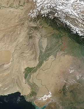
http://en.wikipedia.org/wiki/Gandhara
Gandhāra
, Gandḥārā; also known as ویهیند Waihind in Persian)[1] is the name of an ancient kingdom (Mahajanapada), located in northern Pakistan and eastern Afghanistan. Gandhara was located mainly in the vale of Peshawar, thePotohar plateau (see Taxila) and on the Kabul River. Its main cities were Purushapura (modern Peshawar), literally meaning City of Man[2] and Takshashila (modern Taxila).[3]The Kingdom of Gandhara lasted from early 1st millennium BC to the 11th century AD. It attained its height from the 1st century to the 5th century under the Buddhist Kushan Kings. The Hindu Shahi, a term used by history writer Al-Biruni[4] to refer to the ruling Hindu dynasty[5] that took over from the Turki Shahi and ruled the region during the period prior to Muslim conquests of the tenth and eleventh centuries. After it was conquered by Mahmud of Ghazni in 1021 CE, the name Gandhara disappeared. During the Muslim period the area was administered fromLahore or from Kabul. During Mughal times the area was part of Kabul province.

 Female spouted figure, terracotta, Charsadda, Gandhara, 3rd–1st century BC Victoria and Albert Museum
 Mother Goddess (fertility divinity), derived from theIndus Valley tradition,terracotta, Sar Dheri, Gandhara, 1st century BC,Victoria and Albert Museum
|
Satellite image of the Indus River basin.
|
|
| Countries | China, India, Pakistan |
|---|---|
| Source | Confluence of the Sengge and Gar rivers |
| - location | Tibetan Plateau, Tibet Autonomous Region,China |
| Mouth | Sapta Sindhu |
| - location | Sindh, Pakistan |
| - elevation | 0 m (0 ft) |
| Length | 3,200 km (2,000 mi) approx. |
| Basin | 1,165,000 km² (450,000 sq mi) approx. |
| Discharge | for Arabian Sea |
| - average | 6,600 m3/s (230,000 cu ft/s) approx. |
 Thal Canal from the Indus river, Pakistan
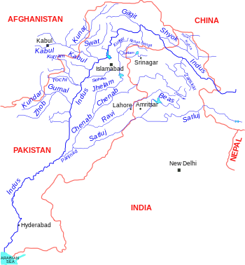
The Indus River (Sanskrit: सिन्धु Sindhu; Sindhi: سنڌو Sindhu; Pashto: اباسين Abāsin “The Father River”; Punjabi: سندھ Sindh; Hindko: سندھ Sindh; Avestan:Harahuti; Arabic: السند Al-Sind; Tibetan: སེང་གེ།་གཙང་པོ; Wylie: Sênggê Zangbo “Lion River”; Chinese: 森格藏布/狮泉河/印度河; pinyin: Sēngé Zàngbù/Shīquán Hé/Yìndù Hé; Greek: Ινδός Indós; Turki: Nilab) is a major river which flows through the northern Indian Subcontinent.
Originating in the Tibetan plateau in the vicinity of Lake Mansarovar in Tibet Autonomous Region, the river runs a course through the Ladakh district of Jammu and Kashmir and then enters Northern Areas (Gilgit-Baltistan), flowing through the North in a southerly direction along the entire length of Pakistan, to merge into the Arabian Sea near the port city of Karachi in Sindh. The total length of the river is 3,180 kilometers (1,976 miles) and it is Pakistan’s longest river.
The river has a total drainage area exceeding 1,165,000 square kilometers (450,000 square miles). The river’s estimated annual flow stands at around 207 cubic kilometers, making it the twenty-first largest river in the world in terms of annual flow. Beginning at the heights of the world with glaciers, the river feeds theecosystem of temperate forests, plains and arid countryside. Together with the rivers Chenab, Ravi, Sutlej, Jhelum, Beas and two tributaries from the Khyber Pakhtunkhwa and Afghanistan, the Indus forms the Sapta Sindhu (Seven Rivers) delta of Pakistan.
Description
The Indus provides the key water resources for the economy of Pakistan - especially the Breadbasket of Punjab province, which accounts for most of the nation’s agricultural production, and Sindh. The word Punjab is a \ word panj meaning Five, and āb meaning Water, giving the literal meaning of the Land of the Five Rivers. The Five rivers after which Punjab is named are the Jhelum, Chenab, Ravi, Beas and the Sutlej. The river also supports many heavy industries and provides the main supply of potable water in Pakistan.
The ultimate source of the Indus is in Tibet; it begins at the confluence of the Sengge and Gar rivers that drain the Nganglong Kangri and Gangdise Shan mountain ranges. The Indus then flows northwest through Ladakh and Baltistan into Gilgit, just south of the Karakoram range. The Shyok River, Shigar and Gilgit streams carry glacial waters into the main river. It gradually bends to the south, coming out of the hills between Peshawar and Rawalpindi. The Indus passes gigantic gorges 4,500-5,200 meters (15,000-17,000 feet) deep near the Nanga Parbat massif. It flows swiftly across Hazara, and is dammed at the Tarbela Reservoir. The Kabul River joins it near Attock. The remainder of its route to the sea is in plains of the Punjab and Sindh, and the river becomes slow-flowing and highly braided. It is joined byPanjnad River at Mithankot. Beyond this confluence, the river, at one time, was named Satnad River (Sat = seven, Nadi = river), as the river was now carrying the waters of the Kabul River, the Indus River and the five Punjab rivers. Passing by Jamshoro, it ends in a large delta to the east of Thatta.
The Indus is one of the few rivers in the world that exhibit a tidal bore. The Indus system is largely fed by the snows and glaciers of the Himalayas, Karakoram and the Hindu Kush ranges of Tibet, the state of Jammu and Kashmir and the Northern Areas of Pakistan respectively. The flow of the river is also determined by the seasons - it diminishes greatly in the winter, while flooding its banks in the monsoon months from July to September. There is also evidence of a steady shift in the course of the river since prehistoric times - it deviated westwards from flowing into the Rann of Kutch and adjoining Banni grasslands after the 1816 earthquake[1][2].
Effects of climate change on the river
The Tibetan Plateau contains the world’s third-largest store of ice. Qin Dahe, the former head of the China Meteorological Administration, said the recent fast pace of melting and warmer temperatures will be good for agriculture and tourism in the short term, but issued a strong warning:
“Temperatures are rising four times faster than elsewhere in China, and the Tibetan glaciers are retreating at a higher speed than in any other part of the world…. In the short term, this will cause lakes to expand and bring floods and mudflows. . . . In the long run, the glaciers are vital lifelines of the Indus River. Once they vanish, water supplies in Pakistan will be in peril.”[3]
“There is [sic] insufficient data to say what will happen to the Indus,” says David Grey, the World Bank’s senior water advisor in South Asia. “But we all have very nasty fears that the flows of the Indus could be severely, severely affected by glacier melt as a consequence of climate change,” and reduced by perhaps as much as 50 percent. “Now what does that mean to a population that lives in a desert [where], without the river, there would be no life? I don’t know the answer to that question,” he says. “But we need to be concerned about that. Deeply, deeply concerned.” [4]
History

Paleolithic sites have been discovered in Pothohar near Pakistan’s capital Islamabad, with the stone tools of the Soan Culture. In ancient Gandhara, near Islamabad, evidence of cave dwellers dated 15,000 years ago has been discovered at Mardan.
The major cities of the Indus Valley Civilization, such as Harappa and Mohenjo-daro, date back to around 3300 BC, and represent some of the largest human habitations of the ancient world. The Indus Valley Civilization extended from across Pakistan, with an upward reach from east of Jhelum River toRopar on the upper Sutlej. The coastal settlements extended from Sutkagan Dor at the Pakistan, Iran border to kutch in easternmost Pakistan. There is an Indus site on the Amu Darya at Shortughai in northern Afghanistan, and the Indus site Alamgirpur at the Hindon River is located only 28 km fromDelhi. To date, over 1,052 cities and settlements have been found, mainly in the general region of the Ghaggar-Hakra River and its tributaries. Among the settlements were the major urban centers of Harappa and Mohenjo-daro, as well as Lothal, Dholavira, Ganeriwala, and Rakhigarhi. Only 90-96 of the over-800 known Indus Valley sites have been discovered on the Indus and its tributaries. The Sutlej, now a tributary of the Indus, in Harappan times flowed into the Ghaggar-Hakra River, in the watershed of which were more Harappan sites than along the Indus.
Most scholars believe that settlements of Gandhara grave culture of the early Indo-Aryans flourished in Gandhara from 1700 BC to 600 BC, when Mohenjo-daro and Harappa had already been abandoned.
The name Indus is used in Arrian’s Indica for the mighty river crossed by Alexander, based on Nearchus’s contemporaneous account. “Indus” is a Hellenic derivative of the IranianHindu, in turn derived from Sindhu, the name of the Indus in the Rigveda. The Sanskrit Sindhu generically means river, stream, ocean, probably from a root sidh meaning to keep off; Sindhu is attested 176 times in the Rigveda, 95 times in the plural, more often used in the generic meaning. Already in the Rigveda, notably in the later hymns, the meaning of the word is narrowed to refer to the Indus river in particular, for example in the list of rivers of the Nadistuti sukta. This resulted in the anomaly of a river with masculine gender: all other Rigvedic rivers are female, not just grammatically, being imagined as goddesses and compared to cows and mares yielding milk and butter.
The Indus has formed a natural boundary between the Indian Subcontinent and its frontier with the Iranian Plateau, a region which includes Pakistan’s Balochistan, Khyber Pakhtunkhwa as well as Afghanistan,Tajikistan and Iran. It has been crossed by the armies of Alexander the Great - His Macedonian forces retreated along the southern course of the river at the end of the Asian campaign after conquering what is nowPakistan and joining it to the Hellenic Empire. The Indus plains have also been under the domination of the Persian empire and the Kushan empire. The Muslim armies of Muhammad bin Qasim, Mahmud of Ghazni,Mohammed Ghori, Tamerlane and Babur also crossed the river to strike into the inner regions of Punjab , Rajasthan and Gujarat.
The word “India” is derived from the Indus River. In ancient times, “India” initially referred to the region of Pakistan along the eastern banks of the Indus river, but by 300 BC, Greek writers like Megasthenes applied the term to the subcontinent which extends further eastward.[5]
The traditional source of the river is the Senge Khabab or ‘Lion’s Mouth’, a perennial spring, not far from the sacred Mount Kailash, and is marked by a long low line of Tibetan chortens. There are several other tributaries nearby which may possibly form a longer stream than Senge Khabab, but unlike the Senger Khabab, are all dependent on snowmelt. The Zanskar River which flows into the Indus in Ladakh has a greater volume of water than the Indus itself before that point.[6]
- “That night in the tent [next to Senge Khabab] I ask Sonmatering which of the Indus tributaries which we crossed this morning is the longest. All of them, he says, start at least a day’s walk away from here. The Bukhar begins near the village of Yagra. The Lamolasay’s source is in a holy place: there is a monastery there. The Dorjungla is a very difficult and long walk, three days perhaps, and there are many sharp rocks; but it its water is clear and blue, hence the tributary’s other name, Zom-chu, which Karma Lama translates as ‘Blue Water’. The Rakmajang rises from a dark lake called the Black Sea.
- One of the longest tributaries — and thus a candidate for the river’s technical source — is the Kla-chu, the river we crossed yesterday by bridge. Also known as the Lungdep Chu, it flows into the Indus from the south-east, and rises a day’s walk from Darchen. But Sonamtering insists that the Dorjungla is the longest of the ‘three types of water’ that fall into the Seng Tsanplo [’Lion River’ or Indus].”[7]
 Extent and major sites of the Indus Valley Civilization in pre-modern Pakistan and northern India 3000 BC.
Geography
Tributaries
- Astor River
- Balram River
- Gar River
- Ghizar River
- Gilgit River
- Gumal River
- Kabul River
- Panjnad River
- Shingo River[citation needed]
- Shigar River
- Shyok River
- Suru River
- Swaan River
- Tanubal River
- Zanskar River
Geology

The Indus River feeds the Indus submarine fan, which is the second largest sediment body on the Earth at around 5 million cubic kilometres of material eroded from the mountains. Studies of the sediment in the modern river indicate that the Karakoram Mountains in northern Pakistan are the single most important source of material, with the Himalayas providing the next largest contribution, mostly via the large rivers of the Punjab (i.e., the Jhelum, Ravi, Chenab, Beas and the Sutlej). Analysis of sediments from the Arabian Sea has demonstrated that prior to five million years ago the Indus was not connected to these Punjab rivers which instead flowed east into the Ganga and were captured after that time[8]. Earlier work showed that sand and silt from western Tibet was reaching the Arabian Sea by 45 million years ago, implying the existence of an ancient Indus River by that time[9]. The delta of this proto-Indus river has subsequently been found in the Katawaz Basin, on the Afghan-Pakistan border. The Indus according to the ancient Rigveda is the Saraswati which flowed from the Himalayas through Pakistan to the Arabian Sea.
In the Nanga Parbat region, the massive amounts of erosion due to the Indus river following the capture and rerouting through that area is thought to bring middle and lower crustal rocks to the surface[10].
Wildlife

Accounts of the Indus valley from the times of Alexander’s campaign indicate a healthy forest cover in the region, which has now considerably receded. The Mughal EmperorBabur writes of encountering rhinoceroses along its bank in his memoirs (the Baburnama). Extensive deforestation and human interference in the ecology of the Shivalik Hills has led to a marked deterioration in vegetation and growing conditions. The Indus valley regions are arid with poor vegetation. Agriculture is sustained largely due to irrigation works.
The blind Indus River Dolphin (Platanista gangetica minor) is a sub-species of dolphin found only in the Indus River. It formerly also occurred in the tributaries of the Indus river. Palla fish (Hilsa) of the river is a delicacy for people living along the river. The population of fishes in the river is moderately high, with Sukkur, Thatta and Kotri being the major fishing centres - all in the lower Sindh course. But damming and irrigation has made fish farming an important economic activity. Located southeast of Karachi, the large delta has been recognised by conservationists as one of the world’s most important ecological regions. Here the river turns into many marshes, streams and creeks and meets the sea at shallow levels. Here marine fishes are found in abundance, including pomfret and prawns.
Economy
The Indus is the most important supplier of water resources to the Punjab and Sindh plains - it forms the backbone of agriculture and food production in Pakistan. The river is especially critical as rainfall is meagre in the lower Indus valley. Irrigation canals were first built by the people of the Indus valley civilization, and later by the engineers of the Kushan Empire and the Mughal Empire. Modern irrigation was introduced by the British East India Company in 1850 - the construction of modern canals accompanied with the restoration of old canals. The British supervised the construction of one of the most complex irrigation networks in the world. The Guddu Barrage is 1,350 metres (4,450 ft) long - irrigating Sukkur, Jacobabad, Larkana and Kalat. The Sukkur Barrage serves over 20,000 square kilometres (5,000,000 acres).
After the independence of Pakistan, a water control treaty signed between India and Pakistan in 1960 guaranteed that Pakistan would receive water from the Indus River and its two western tributaries, the JhelumRiver & the Chenab River independent of upstream control by India.[11] The project, Indus Basin Project, consisted primarily of the construction of two main dams, the Mangla Dam built on the Jhelum River and theTarbela Dam constructed on the Indus River, together with their subsidiary dams.[12] The Pakistan Water and Power Development Authority undertook the construction of the Chashma-Jhelum link canal - linking the waters of the Indus and Jhelum rivers - extending water supplies to the regions of Bahawalpur and Multan. Pakistan constructed the Tarbela Dam near Rawalpindi - standing 2743 metres (9,000 ft) long and 143 metres (470 ft) high, with an 80 kilometre (50 mile) long reservoir. The Kotri Barrage near Hyderabad is 915 metres (3,000 ft) long and provides additional supplies for Karachi. The Taunsa Barrage near Dera Ghazi Khan produces 100,000 kilowatts of electricity. The extensive linking of tributaries with the Indus has helped spread water resources to the valley of Peshawar, in the Khyber Pakhtunkhwa. The extensive irrigation and dam projects provide the basis for Pakistan’s large production of crops such as cotton, sugarcane and wheat. The dams also generate electricity for heavy industries and urban centres.
People
 The inhabitants of the regions through whom the Indus river passes and forms a major natural feature and resource are diverse in ethnicity, religion, national and linguistic backgrounds. On the northern course of the river in the province of Jammu and Kashmir live the Buddhist people of Ladakh, of Tibetan stock, and the Dards of Indo-Aryan orDardic stock and practising Buddhism and Islam. Then it descends into Baltistan, northern Pakistan passing the main Balti city of Skardu. As it continues through Pakistan, the Indus river forms a distinctive boundary of ethnicity and cultures - upon the western banks the population is largely Pashtun, Baloch, and of other Iranic stock, with close cultural, economic and ethnic ties to eastern Afghanistan and parts of Iran. The eastern banks are largely populated by peoples of Indo-Aryan stock, such as the Punjabis and the Sindhis. In northern Punjab and the Khyber Pakhtunkhwa, ethnic Pashtun tribes live alongside Dardic people in the hills (Khowar, Kalash, Shina, etc.), Burushos (inHunza), and Punjabi people.In the province of Sindh, peoples of Sindhi backgrounds form the local populations. Upon the western banks of the river live the Baloch andPashtun peoples of Balochistan
Modern issues
 False-colour image of flooding along the river.
The Indus is a strategically vital resource for Pakistan’s economy and society. After the independence of India and Pakistan in 1947, the use of the waters of the Indus and its five eastern tributaries became a major dispute between India and Pakistan. The irrigation canals of the Sutlej valley and the Bari Doab were split - with the canals lying primarily in Pakistan and the headwork dams in India disrupting supply in some parts of Pakistan. The concern over India building large dams over various Punjab rivers that could undercut the supply flowing to Pakistan, as well as the possibility that India could divert rivers in the time of war, caused political consternation in Pakistan. Holding diplomatic talks brokered by the World Bank, India and Pakistan signed the Indus Waters Treaty in 1960. The treaty gave India control of the three easternmost rivers of the Punjab, the Sutlej, the Beas and the Ravi, while Pakistan gained control of the three western rivers, the Jhelum, the Chenab and the Indus. India retained the right to use of the western rivers for non irrigation projects. (See discussion regarding a recent dispute about a hydroelectric project on the Chenab (not Indus) known as the Baglihar Project).
Hindu pilgrimage to holy sites alongside the river has been a source of conflict between the two nations. Pakistan and India do not generally allow each others’ citizens to cross borders for religious pilgrimages, other than Sikhs who travel to Pakistan for their annual pilgrimage.
There are concerns that extensive deforestation, industrial pollution and global warming are affecting the vegetation and wildlife of the Indus delta, while affecting agricultural production as well. There are also concerns that the Indus river may be shifting its course westwards - although the progression spans centuries. On numerous occasions, sediment clogging owing to poor maintenance of canals has affected agricultural production and vegetation. In addition, extreme heat has caused water to evaporate, leaving salt deposits that render lands useless for cultivation.
Recently, Pakistani politicians, and even jihadist groups, have alleged that India is building dams on the river in violation of the Indus Waters Treaty, reducing water flow into Pakistan. This has lead to straining relations between the two countries further.
Sindhu Darya Day (River Indus Day)
Sindhu Darya Day (River Indus Day) was first celebrated on 24 January 2010 in Sindh in tribute to the River Indus. The Government of Sindh has decided to celebrate this day every year.
The day was announced by the Sindhi TV channel KTN, and later by Chief Minister Sindh Syed Qaim Ali Shah. The main reason to observe this day was to raise awareness among people about the critical situation of the Indus and to motivate people to work to make restoration of water in the river possible.
A large number of women and children, activists of various political parties, including the PPP, the PML-N, the PML-F, the MQM, nationalist groups, labour federations and non-governmental organisations, wearing Sindhi caps and ajraks and keeping aside their political affiliations and ideologies, tossed flowers and rose petals into the Indus River and its related canals.
People started assembling at the riverbed at about 10 am and remained there till evening when prayers were offered for restoration of the river’s old glory. They gathered at almost all the places in Sindh from where River Indus flows to express their love for the river and reiterate their stand on the water issue.
People from Tharparkar belonging to the Bheel, Kohli and Thakur communities also offered prayers according to their traditions and danced to the tune of national andSindhi songs.
Different groups presented cultural programs on the occasion to motivate people about preserving the historic importance, uniqueness and continued flow of the river. Several organisations had set up camps and stalls and some of them distributed free food. A 12-year-old boy also paid tribute of blood to the river in Sukkur.
In Thatta, activists of social and political organisations and civil society sat in the dry riverbed and held a demonstration on Doolha Darya Khan bridge to express concern over shortage of water in the river.
Sindhis belonging to India, who came to Sindh for their own religious purposes, also celebrated this day when they heard of this call. They threw roses in the river at Saadh Belo, Sukkur.
The Hindu community of Sindh also celebrated this day in their own unique religious way. They took Aartee of River Indus and decided to celebrate this day every year as a religious day.
Many local and famous singers of Sindh, including Ahmed Mughal, Zamin Ali, Taj Mastani, Sadiq Faqir, Kareem Faqir, Najaf Faqir, Sanam Marvi, Zulfiqar Ali and Mazhar Hussain, entertained people from a stage set up by the Sindh Department of Culture.
Large groups of people holding flags and banners of different parties marched to the river on foot and many other in motorcade. They were led by their leaders, STP chairman Qadir Magsi, JSQM chairman Bashir Khan Qureshi, JSM chairman Riaz Chandio, Culture Minister Sassui Palijo, MPA Humera Alwani, Dr Mahesh kumar Malani PPP MNA from Tharparkar, MNA Dr Abdul Wahid Soomro, MNA Syed Ayaz Shah Shirazi and MPA Heer Soho. Several NGOs and welfare organisations also held rallies, which were attended by writers, intellectuals, fishermen and common people.
Leaders of different political and social organizations said thousands of acres of agricultural land of the province became barren due to the scarcity of water. They said the people of Sindh depended on the Indus River, because the river irrigated their lands and kept the water ecology intact. They said the observance of the Indus Day was not a politically motivated object, but that the object of the day was to unite the people of Sindh to exert pressure on the authorities concerned to take notice of the shortage of irrigation water.
They said such days also promoted the culture and tradition of nations while bridging the gap between the people. They pledged to continue such observances annually and asked the authorities concerned to devise a strategy to produce more water reservoirs.
[edit]2010 floods
 Affected areas as of August 26, 2010
 Coin of Early Gandhara Janapada: AR Shatamana and one-eighth Shatamana (round), Taxila-Gandhara region, ca. 600–300 BC
 Portraits from the site of Hadda, Gandhara, 3rd century, Guimet Museum
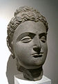 Buddha head (2nd century)
 Buddha in acanthuscapital
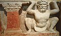
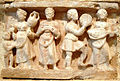 Wine-drinking and music,Hadda (1st–2nd century)
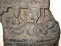 Maya’s white elephant dream (2nd–3rd century)
 The birth of Siddharta (2nd–3rd century)
 The Great Departure from the Palace (2nd–3rd century)
 The end of ascetism (2nd–3rd century)
 The Buddha preaching at the Deer Park in Sarnath(2nd–3rd century
 Scene of the life of the Buddha (2nd–3rd century)
 The death of the Buddha, or parinirvana (2nd–3rd century)
 A sculpture from Hadda, (3rd century)
 The Bodhisattva and Chandeka, Hadda (5th century)
 Hellenistic decorative scrolls from Hadda, northern Pakistan
 Hellenistic scene, Gandhara (1st century)
 A stone plate (1st century